Trail Walking Le Lorrain - Plateau Morne Capot en boucle via Fond Labour - Photo

Plateau Morne Capot en boucle via Fond Labour

 Lamartiniere
Lamartiniere

User GUIDE

© OpenStreetMap contributors
Length
Length
4.5 km
Max alt
Max alt
282 m
Uphill gradient
Uphill gradient
128 m
Km-Effort
Km-Effort  
6.2 km
Min alt
Min alt
178 m
Downhill gradient
Downhill gradient
128 m
Boucle
Boucle
Yes
Creation date :
2023-09-05 20:24:46.077
Updated on :
2023-09-05 21:42:16.042

(0 Reviews)

Walking
Walking
1h24
Difficulty : Medium

Scan this QR Code to open this trail in the SityTrail application

FREE GPS app for hiking

Logo SityTrail SityTrail

IGN / Geographical institutes

Download SityTrail from the App Store Download SityTrail from Google Play

Logo SityTrail SityTrail World

The world is yours!

Download SityTrail from the App Store Download SityTrail from Google Play Download SityTrail on Huawei AppGallery

About

Trail Walking of 4.5 km to be discovered at Martinique, Unknown, Le Lorrain. This trail is proposed by Lamartiniere.

Description

Randonnée prévue Samedi 9 Septembre 2023 lors de la réunion des Présidents de clubs affiliés  au  Comité de la Randonnée pédestre (CRPM).  Cette journée de travail se tiendra  à l' Océanic-club du Morne Capot, Le Lorrain. Préparation rando également pour des stagiaires. Attention,  passages sur les terrains privés avec autorisations des propriétaires.

Elevation profile

Photos

Positioning

Country:
France
Region :
Martinique
Department/Province :
Unknown
Municipality :
Le Lorrain
Location:
Unknown
Start:(UTM)
704714 ; 1639395 (20P) N.

Trails nearby

Trail Walking Le Morne-Rouge - Mac Intoch - Morne Capot - Photo
Walking
GUIDE
Lamartiniere

Walking

Medium
(1)
Le Morne-Rouge, Martinique, Unknown, France
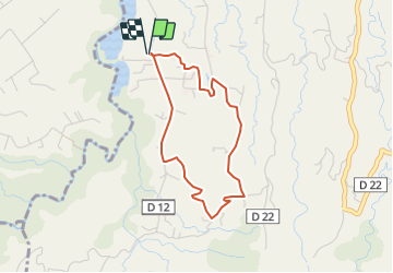
9.4 km | 14.9 km-effort
4h 53min
No
Trail Walking Basse-Pointe - Exploitations agricoles en boucle N°1 - Photo
Walking
GUIDE
Lamartiniere

Walking

Medium
Basse-Pointe, Martinique, Unknown, France
13.2 km | 16.5 km-effort
4h 0min
Yes
Trail Walking Le Lorrain - Fond capot oceanic fond cani morne Degras - Photo
Walking
GUIDE
manuelPerez

Walking

Le Lorrain, Martinique, Unknown, France
8.5 km | 11.9 km-effort
3h 44min
Yes
Trail Walking Le Lorrain - Mornes Capot / Lorrain Martinique - Photo
Walking
GUIDE
GabyG

Walking

Medium
(1)
Le Lorrain, Martinique, Unknown, France
8.5 km | 11.8 km-effort
3h 41min
Yes
Trail Walking Basse-Pointe - Boucle de chalvet, Pécoule vers Chalvet. - Photo
Walking
GUIDE
GabyG

Walking

Medium
Basse-Pointe, Martinique, Unknown, France
6.5 km | 7.8 km-effort
3h 2min
Yes
Trail Walking L'Ajoupa-Bouillon - Défi 2022 étoile - Photo
Walking
GUIDE
manuelPerez

Walking

L'Ajoupa-Bouillon, Martinique, Unknown, France
9.1 km | 15.6 km-effort
3h 33min
No
Trail Walking Le Lorrain - Morne Jacob au Panneau ONF - Photo
Walking
GUIDE
Lamartiniere

Walking

Medium
Le Lorrain, Martinique, Unknown, France
4.3 km | 8.7 km-effort
2h 0min
No
Trail Walking Le Lorrain - trace des Amérindiens - Photo
Walking
GUIDE
GabyG

Walking

Medium
Le Lorrain, Martinique, Unknown, France
5.1 km | 6.6 km-effort
2h 40min
No
Trail Walking Le Lorrain - Boucle La Crabiere - Hbt Assier - Photo
Walking
GUIDE
Lamartiniere

Walking

Medium
Le Lorrain, Martinique, Unknown, France
8.5 km | 11.7 km-effort
3h 0min
Yes


Close
My subscriptions